highlight:
-
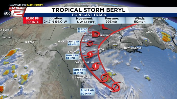
As of Saturday night, Beryl was still a tropical storm in the Gulf of Mexico.
-
The storm is expected to strengthen into a hurricane on Sunday and make landfall near Matagorda Bay early Monday.
-
A recent shift in Beryl’s forecasted path to the east will result in significantly less rainfall in San Antonio.
-
Rainfall varies significantly across the region. The east side has seen more precipitation, while the San Antonio area and the west side tend to be drier.
-
Still, gusty winds are possible throughout the day Monday, especially along and east of I-35.
Beryl’s Change of Course:
Beryl’s path has recently been moving eastward, meaning it will likely make landfall Sunday night into Monday morning, directly impacting the area between Corpus Christi and Matagorda Bay.
There are a few key takeaways from this new development: First, if the storm stays out to sea a little longer (either moving along the Texas coast or inland), it could intensify further and cause more severe coastal impacts.
moreover, This eastward movement will put San Antonio on the drier side of the storm.As a result, precipitation decreased.
San Antonio Beryl Scenario:
This is important because Beryl’s track could still change between now and landfall. On its current track, Monday will likely bring periods of light rain and gusty winds for San Antonio, but there is still some potential…
-
If Beryl moves west: This means more rain in the Alamo City on Monday, along with wind gusts that could reach up to 60 mph.
-
If Beryl moves East: This means no rain in San Antonio, and temperatures will be much warmer.
Beryl’s position only needs to swing by a few miles to determine locally whether heavier rain falls on Monday.
Bottom line: Keep checking back for updates, we’ll be following this closely through the latter part of the weekend.
Beryl scenario in the Eastern counties:
If it stays on its current path, far eastern counties (specifically Lavaca, DeWitt and Gonzales counties) will see increased precipitation and stronger wind gusts by the time it’s all said and done.
Saturday evening’s forecast calls for winds of 40-50 mph and gusts of over 70 mph in the area on Monday. Rainfall amounts of 3-4 inches (localized amounts of 6-10 inches) are not ruled out. If this prediction proves correct, some flooding issues will be worth watching.
However, it is worth pointing out that these ranges could be affected if Beryl’s path changes again.
Meanwhile, flood watches and tropical storm watches have been issued for Lavaca and DeWitt counties.
Texas coast affected Sunday/Monday
It’s expected to make landfall near Matagorda Bay early Monday morning, but it’s still not a good weekend to travel anywhere along the Texas coast.
Regardless of where landfall occurs, much of the Texas coast will experience rain, high surf, rip currents, and at least some storm surge.
Much of the Texas coast from Bay City to Corpus Christi is under a hurricane warning until Beryl passes.
KSAT Weather Station
Download the KSAT 12 Weather App on your smartphone to get the latest weather alerts. You can also check out our forecasts, livestream and interactive maps on KSAT.com.
Want to share what you’re seeing with KSAT12 meteorologists? Submit your photos or videos here and they could be featured on KSAT.com or on air.
resource:
Copyright 2024 by KSAT – All rights reserved.

